Fire activity and burned forest lands decreased during the last three decades in Spain
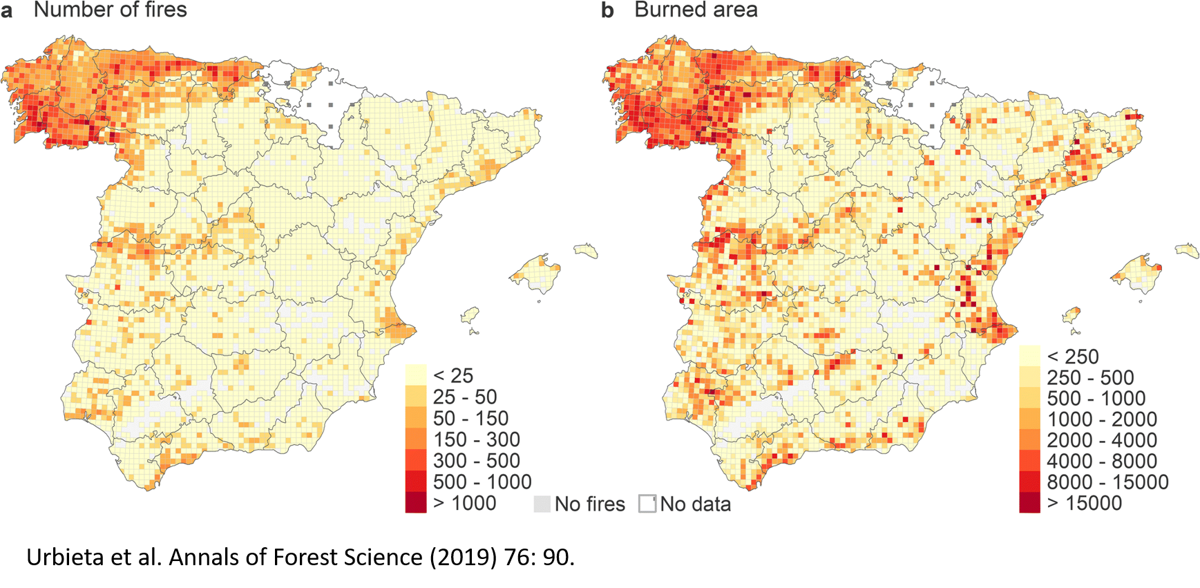
a Total number of fires and b total burned area (ha) per 10 × 10 km grid cell accumulated for 1980–2013 in Peninsular Spain and the Balearic Islands
Fire activity has decreased in the last decades in Spain as a whole and in most provinces. However, fire risk factors have increased. Wildfires are burning preferentially treeless areas. Flammable pine areas burn less, while the less flammable oak forests burn more. This decreasing fire activity coincides with increasing fire suppression resources.
Context Climate and other fire risk factors are changing across the world, including the Mediterranean region. It is important to determine how fire activity is responding to such changes.
Aims To identify spatio-temporal changes in fire frequency and size, main tree species burned, and their association with changes in climate, land-use and land-cover, and fire suppression.
Methods Analysis of trends, breakpoints, and association among the time series of fire variables and fire risk factors during 1980–2013 in Spain at country and provincial levels.
Results Wildfires in Spain have been decreasing in number, burned area, mean, and largest fire sizes. Fires are more frequently burning treeless areas than forests. Pine forests are burning less, while oak forests are burning more. Fire suppression resources, particularly aerial ones, increased significantly. Risk factors like the mean summer fire weather index, and the forested and the artificial areas all increased.
Conclusion Despite increasing fire risk factors, wildfires have decreased at the country as a whole and in most provinces in Spain during the last 34 years.
Keywords
Climate change, Fire risk, Fire suppression, Fire weather, Land-use and land-cover change
Publication
Urbieta, I.R., Franquesa, M., Viedma, O. et al. Annals of Forest Science (2019) 76: 90. https://doi.org/10.1007/s13595-019-0874-3
For the read-only version of the full text: https://rdcu.be/bPOKj
Data availability
The datasets analyzed during the current study are available from the corresponding author on reasonable request. The data can be requested from the following sources: Spanish National Forest Fire Statistics (EGIF) from the Spanish Ministry of Agriculture, Fisheries and Food; Daily meteorological data from the reanalysis of WFDEI (WATCH-Forcing-Data- 111 ERA-Interim) (Weedon et al. 2014); LULC data from CORINE Land Cover Project at https://land.copernicus.eu/pan-european/corine-land-cover.